2012-09-12

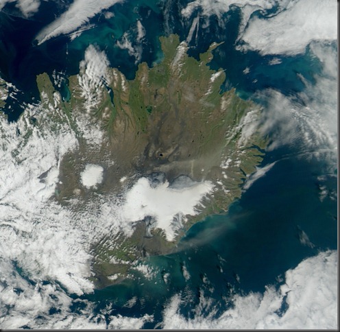
Ash / dust storm on 10 and 11 September from Mýrdalssandur and other locations on the south coast of Iceland

Strong wind and dry weather are an ideal combination for ash/dust storms.

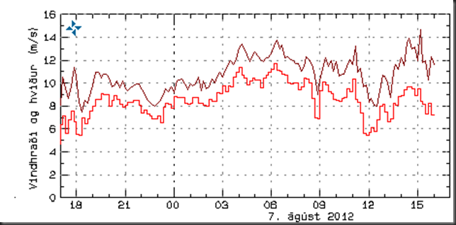
Windspeed at Kvísker (figure below) and Kirkjubæjarklaustur well over 15 m/s and even stronger gusts.

20120911_0905_KviskerVindur

Data from the IMO web site.

20120910_modis_truecol_P20122541420

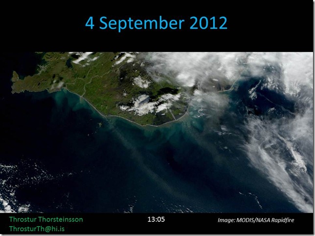
Satellite image take at 14:20 on 10 September (MODIS/NASA Rapidfire via IMO). Clearly visible broad plume of ash/dust reaching to the south-east.

20120911_modis_truecol_P20122551505

Satellite image taken at 15:05 on 11 September 2012 (MODIS/NASA Rapidfire via IMO).

2012-08-07

Duststorms north and south of Vatnajökull

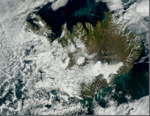
Today there are visible dust storms from north of Dyngjujökull (Vatnajökull) and Ingólfshöfði, south of Vatnjökull.

Wind speed at Sandbúðum, east of Hofsjökull, has been around 10 m/s – especially for gusts.

image

Below are MODIS satellite images from NASA/IMO since:

12:40

20120807_modis_truecol_A2012220124020120807_modis_btd_A20122201240

14:35

20120807_modis_truecol_P20122201435

2012-07-24

Unbelievable surface melt extent for Greenland

New data, combining observations from 3 different satellites, show that almost the whole surface of the Greenland glaciers was melting on 12 July 2012. It is not clear still whether most of this will refreeze, or contribute to this seasons annual melting.

The image pair below shows the situation on 8 and 12 July 2012. The 8th of July case is typical for the last few years, with nearly half of the surface experiencing some melt, but the 12th of July is extraordinary. But, like mentioned above, the net effect of this remains to be seen. This might be a short lived event, or not …

Credit: Nicolo E. DiGirolamo, SSAI/NASA GSFC, and Jesse Allen, NASA Earth Observatory

2012-07-10

Wildfire at Snæfellsnes

The wildfire yesterday at Snæfellsnes is seen on a satellite image (MODIS image from NASA) at 21:15 on 9 July 2012. The location is to the east on the southern part of the peninsula, see map below.

Sinueldur á Snæfellsnesi, 9. júlí 2012.

The weather in Stykkishólmur on Monday at 21:00 (from IMO vedur.is).
Wind: image 9 m/s, temperature: 10,6 °C, precipitation 0 mm / 1 hour, humidity: 57 % and visibility >70 km.

Which fits nicely with this being the smoke from the wildfire which is seen in the image above.

Raudkollsstadir_Snaefellsnes_LMIkort

Here is the location of Rauðkollsstaðir the closest farm to the wildfire (map from LMI.is) which also fits nicely with this being the smoke from the wildfire Smile

Here are finally couple of news (in Icelandic, but some with pictures) about the wildfire: