2014-09-16

Seasonality of wildfires in Iceland

In the next volume of Náttúrufræðingsins, 84(1-2): 19-26, there is an article about the seasonality of wildfires in Iceland.

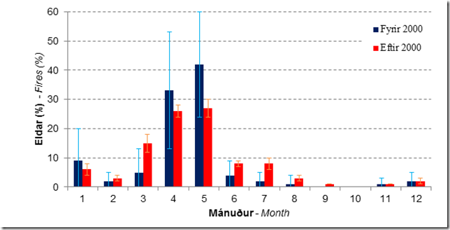
Summary. Data on wildfires was collected from news databases, and for the period 2003–2010 we had data from the Iceland Construction Authority, which contains the activity of all fire departments in Iceland. Most of the fires are small; however, there were ten wildfires larger than 1 hectare in the period 2007–2013, including six larger than 10
hectares. Most of the fires are due to ignition, deliberate or accidental. There is a clear seasonal signal in the occurrence of wildfires in Iceland using data from 1943–2012. Most often they occur in spring, with 29% of each year wildfires occurring in May, followed by 28% in April and 13% in March. There is also a clear New Year’s Eve signal in January (6% of the wildfires). The data is not detailed enough to allow estimation of changes in frequency or occurrence between months, since prior to 2002/3 there was no centralized registration of wildfires. However, one can infer that wildfire during the summer months is a relatively recent development. This fits well with increased biomass
due to global warming, denser summerhouse populations, and less grazing. This also exemplifies the need for action in developing risk assessments and including wildfires in
planning.

image

The distribution of wildfires each month for the period 1943–2000 (blue columns; 161 events) and 2001–2012 (red columns; 947 events), and standard deviation.
2014-09-07

Eruption in Holuhraun and air quality considerations

The eruption in Holuhraun (Holu-lava field) has now been active for just over a week; since 31 Agust (if I remember correctly).

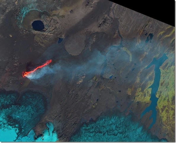
There is a fair bit of lava that has been extruded, as can be seen on this Landsat image from NASA. The lava flow is to the right on the figure, from a linear almost N-S fissure. There is a little red spot south of there, that is a new opening. There is a dike running from Bárðarbunga, underneath the glacier, to the eruption site (and even a bit further north). On of the things to look for is whether the fissure will open up underneath the glacier. Some flooding would follow and more explosions as magma and water interact.

20140906_LC82170152014249LGN00_crop
Landsat 8 image from NASA on 6 September 2014.

The lava has reached the glacial river, Jökulsá á Fjöllum, which causes some steam explosions – making it still more difficult for the scientist working in the area.

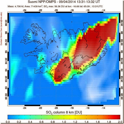
But, one of the concerns, is the air pollution. Especially SO2 gas.

iceland_ompsso2_trm_20140904
SO2 in 8 km of the atmospheric column (NASA).

Fortunately, this is a relatively small eruption.

Measurements in the eastern fjords, at Reyðarfjörður (large fjord middle of image), went up to 250 µg/m3 10-min value on 2 September. That is quite high, given that it is 125 km away from the eruption site, and this is a small eruption.

However, public health limits are 350 µg/m3 for 1-h average, and workers occupation limits are about 5 times higher than that. And real danger, requiring evacuation, seems to be at levels of 10 000 µg/m3.

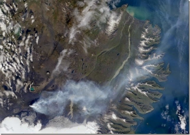
Recent measurements in the eastern fjords indicate that the SO2 concentration is below 300 µg/m3, despite a distinctive blue haze being observed in the area. The haze can be seen quite clearly in the next figure.

20140906_1330_modis_truecol_A20142491330_crop
MODIS image from NASA and IMO from 6 September 2014 at 13:30.

It will be interesting to follow the eruption and see whether: 1) the dike breaks to the surface underneath the glacier, 2) Bárðabunga will erupt, 3) Askja wakens, and erupts, or 4) the whole system simply slowly cools down.

2014-07-13

Fluorine (F) pollution in Reyðarfjörður 2014

image
Image from  http://ust.is/library/Skrar/Atvinnulif/Mengandi-starfsemi/Fluor-Reydarfirdi/Fluormaeling_juni_2_2014.pdf. Number in circles shows the concentration.

The reference value for livestock fodder is 40 µg/g, but as can be seen from the figure, the values are higher in several areas outside the dilution area (yellow line).

Hopefully the aluminum smelter can find ways to reduce this pollution soon.

2014-04-20

Health limits for H2S in Iceland

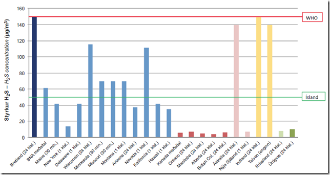
We, Sigurður Björnsson and Þröstur Þorsteinsson, recently published a paper where we compare the health limits for H2S in Iceland with other countries (states within US, and so on).

It is clear that Iceland does not have uniquely strict health limits – despite claim to the contrary by the power companies in the media.

The figure below shows the comparison (click to get a slightly larger image).

image

The Icelandic health limit (green line), the WHO guideline (red line) and standards/guidelines for the countries/states in question. Averaging times are in brackets.

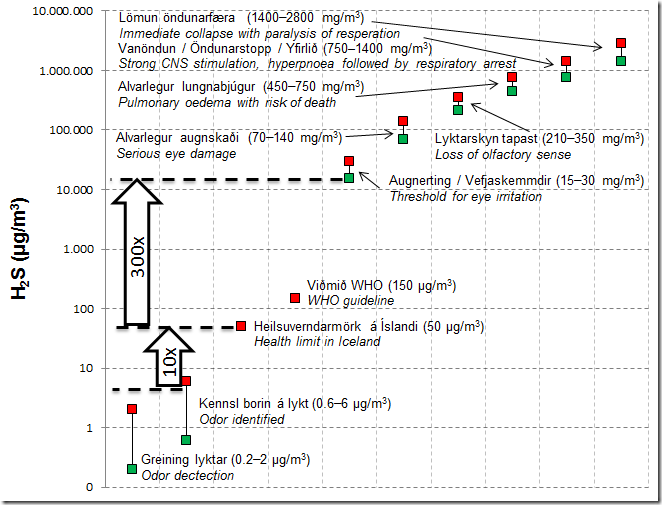
We also gathered on one graph the various effects exposure to high levels of H2S can have, the odor detection limits, and the Icelandic and WHO health limits.

image

Effects of H2S on olfaction and health. If the concentration is similar to the Icelandic
health limit, it has to increase 300 fold for people to experience discomfort due to eye irritation. Red squares are maxima, green squares minima. The scale for the y-axis is logarithmic.

The WHO limit is set to avoid acute effects, and therefore not strictly comparable to the Icelandic limit, which is set to avoid health effects of long term exposure.

Reference

Sigurður Björnsson og Þröstur Þorsteinsson. 2013 (prentað 2014). Heilsuverndarmörk brennisteinsvetnis og styrkur þess á höfuðborgarsvæðinuNáttúrufræðingurinn 83(3-4): 151 - 158.

2014-02-19

Strong easterly wind and lots of particulate matter

Today, 19 February 2014, there has been a very high concentration of PM10 in Reykjavik, and other places in Iceland.

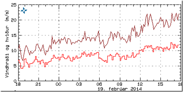
Very strong eastern winds been dominant today, and dry weather – till there was a little bit of flurries in Reykjavik in the afternoon – for instance.

image
The weather conditions at 17, still strong winds. Notice also the division in temperature, below zero in the northern part, and above zero in the southern part of the country.

image
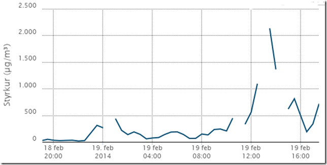
Wind speed in Reykjavík. Notice that when the wind climes up around noon, we see a peak in the PM10 values. Around 16 there were some snow flurries, and that can also be seen in the PM10 values.

Particulate matter (PM10) concentration measured at Grensásvegur (GRE) went quite high today.

image
The highest value is about 2133 µg/m3!


There are also news about a lot of dust/ash being resuspended in the east, around Kirkjubæjarklaustur for instance:
Rykský yfir Kirkjubæjarklaustri

2014-02-11

… and the wind came to the rescue–PM concentration lower in the afternoon

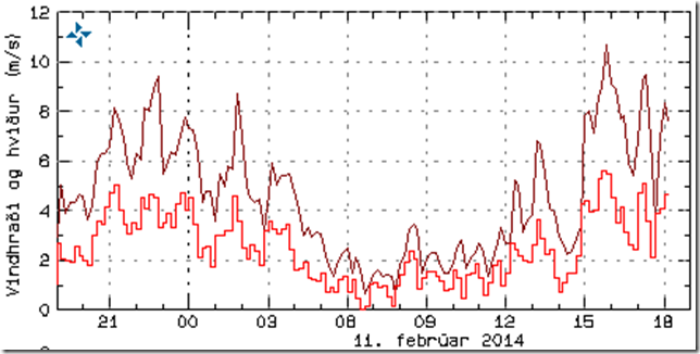
As mentioned earlier today, our best chance of avoiding high levels of PM10 was that the wind would start blowing. And it did Bros

image

We can see that after 12 noon, and especially after 15:00, the wind speed (red line) and gusts (brown line) picked up.

The effect is easily seen on PM10 (blue line), and NOx (yellowish line).

image

It looks as we might exceed the health limit, 50 µg/m3 for 24-hour average?

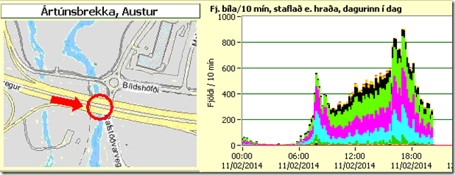
Finally, below are plots of the number of cars driving west and east down Ártúnsbrekka – few kilometers from the measurement station.

West:

image

East:

image

Nice still weather, and a lot of particulate matter

Today is a very nice day here in Reykjavik. Weather is sunny, temperature just below freezing and very calm winds.

image

Windspeed in Reykjavik (data from the IMO). Since about 6 am the windspeed has very calm, under 2 m/s and no gusts.

This unfortunatly also means that the concentration of particulate matter is quite high; at the measurement station at Grensásvegur – at an intersection of two busy streets. The high levels are due to traffic. This is clearly seen by looking at NOx (orange line), which is emitted by cars, and PM10 (blue line).

image

It will be intersting how large the top will be in the afternoon. The only thing that can prevent high concentration is stronger wind or precipitation.