2012-12-24
Merry Christmas
We had plans to measure ultrafine particulates during the fireworks on New Years Eve, but the instrument, which is new, gives us error messages and it seems unlikely that we hear from the manufacturer in time. Very frustrating, a new instrument!
2012-11-23
New article about H2S plume dispersal
New article about the distribution of H2S from geothermal power plants near Reykjavik, and the conditions that lead to concentration above 50 µg/m3.
Throstur Thorsteinsson, Julia Hackenbruch, Einar Sveinbjörnsson, Thorsteinn Jóhannsson. 2013.
Statistical assessment and modeling of the effects of weather conditions on H2S plume dispersal from Icelandic geothermal power plants.
Geothermics 45: 31 - 40. <
Abstract
Episodes of high atmospheric load of hydrogen sulfide (H2S), where the concentration is over 50 μg m−3hourly average value, occur about 80 times a year in Reykjavik (data from 2007 to 2009). H2S originates mainly from two geothermal power plants 25–30 km (south-)east of Reykjavik, at Hellisheidi and Nesjavellir. Certain weather-dependent dispersion conditions, such as wind, cloud cover and air temperature, allow the transport of emissions towards Reykjavik and the neighboring cities, causing local air pollution. High concentrations of H2S occur within a narrow range of weather conditions, namely slow (mean value 2 ± 1 m s−1) easterly (114° ± 23°) winds, together with cold air temperatures (median value −3 °C) and preferably no, or little, cloud cover. A classification of weather types shows the preferred occurrence of high H2S concentrations in connection with low atmospheric exchange and autochthonous weather. Stable atmospheric stratification and inversions enable the transport of H2S emissions to Reykjavik. The measured concentrations, the short lived peaks in concentration and different values at nearby measurement stations, indicate a very narrow plume, which fits well with a Gaussian plume distribution model.
2012-11-01
Sand / ash storm and very high values of PM10 at Raufarfell
Very high levels of PM10 are now recorded at Raufarfell.
Location of Raufarfell.
The concentration of PM10 reached over 900 µg/m3 today, 1 November 2012 (data from VISTA).
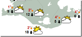
Wind-speed has been very high, at Kvísker for instance (see vedur.is for location of station SE-Iceland).
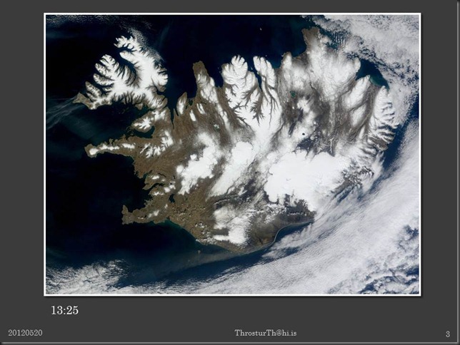
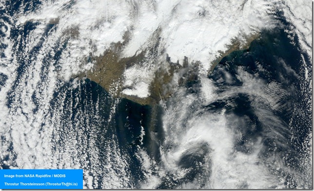
And satellite image from 13:40 today shows that sand and ash is blowing up and out to the ocean from all of the south part of Iceland (MODIS NASA/Rapidfire).
Dust/ash storm
2012-09-12
Ash / dust storm on 10 and 11 September from Mýrdalssandur and other locations on the south coast of Iceland
Strong wind and dry weather are an ideal combination for ash/dust storms.
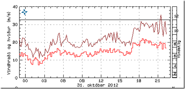
Windspeed at Kvísker (figure below) and Kirkjubæjarklaustur well over 15 m/s and even stronger gusts.
Data from the IMO web site.
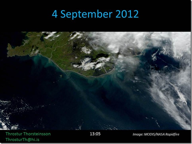
Satellite image take at 14:20 on 10 September (MODIS/NASA Rapidfire via IMO). Clearly visible broad plume of ash/dust reaching to the south-east.
Satellite image taken at 15:05 on 11 September 2012 (MODIS/NASA Rapidfire via IMO).
2012-09-09
2012-08-07
Duststorms north and south of Vatnajökull
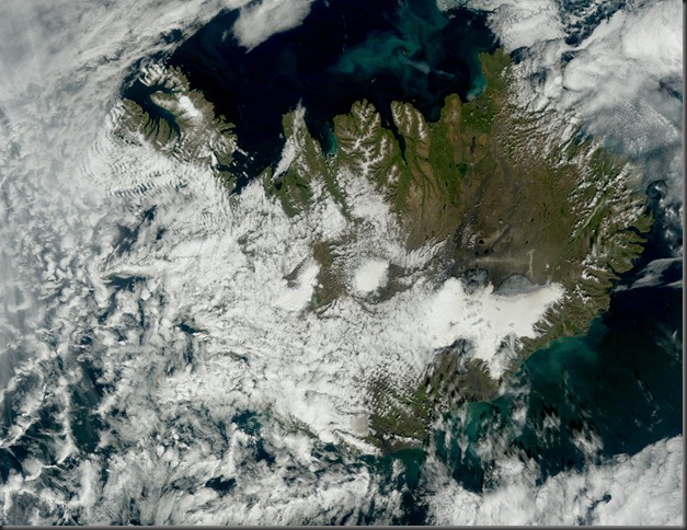
Today there are visible dust storms from north of Dyngjujökull (Vatnajökull) and Ingólfshöfði, south of Vatnjökull.
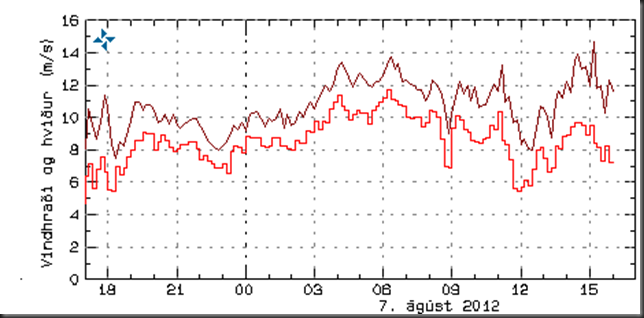
Wind speed at Sandbúðum, east of Hofsjökull, has been around 10 m/s – especially for gusts.
Below are MODIS satellite images from NASA/IMO since:
12:40
14:35
2012-07-24
Unbelievable surface melt extent for Greenland
New data, combining observations from 3 different satellites, show that almost the whole surface of the Greenland glaciers was melting on 12 July 2012. It is not clear still whether most of this will refreeze, or contribute to this seasons annual melting.
The image pair below shows the situation on 8 and 12 July 2012. The 8th of July case is typical for the last few years, with nearly half of the surface experiencing some melt, but the 12th of July is extraordinary. But, like mentioned above, the net effect of this remains to be seen. This might be a short lived event, or not …
Credit: Nicolo E. DiGirolamo, SSAI/NASA GSFC, and Jesse Allen, NASA Earth Observatory
2012-07-10
Wildfire at Snæfellsnes
The wildfire yesterday at Snæfellsnes is seen on a satellite image (MODIS image from NASA) at 21:15 on 9 July 2012. The location is to the east on the southern part of the peninsula, see map below.
The weather in Stykkishólmur on Monday at 21:00 (from IMO vedur.is).
Wind: 9 m/s, temperature: 10,6 °C, precipitation 0 mm / 1 hour, humidity: 57 % and visibility >70 km.
Which fits nicely with this being the smoke from the wildfire which is seen in the image above.
Here is the location of Rauðkollsstaðir the closest farm to the wildfire (map from LMI.is) which also fits nicely with this being the smoke from the wildfire
Here are finally couple of news (in Icelandic, but some with pictures) about the wildfire:
- http://www.ruv.is/frett/barist-vid-sinuelda-a-snaefellsnesi
- http://mbl.is/frettir/innlent/2012/07/10/skurdgrafa_notud_vid_slokkvistarf/
- http://mbl.is/frettir/innlent/2012/07/10/tekist_ad_hefta_utbreidslu_eldsins/
- http://www.ruv.is/frett/sinueldur-haminn-a-snaefellsnesi-myndskeid
- http://www.ruv.is/frett/enn-glod-a-raudkollastodum
2012-06-10
Ash- and dust storms
The last couple of days there has been a lot of Particulate Matter (PM) in the east, and also in the Reykjavik area. This is clear from recent headlines: “Ekki hægt að fara út fyrir svifryki (Not possible to be outside because of PM)” og “Velti bíl í ösku á Skeiðarársandi (Car overturns as it drives into a ash on the road)”.
In Fljótshverfi (south of Vatnajökull, see map) the concentration increased rapidly on 8 June, and was over 100 micro-g per cubic meter around 10, and was very high , over 1000 micro-g per cubic meter around 17:00, but then decreased after that. Stations in Reykjavik showed the ash arriving later in the evening, around 20:30.
On 9 June there were high levels of PM in the Reykjavik area, both due to the ash from east, and also possibly from a dust storm from Landeyjasandur (see image).
The image should be a little bigger if clicked on
2012-05-29
Still some ash and dust blowing around

Image from 12:50 Monday 28 May 2012 (NASA/Rapidfire).
Today in Fljótshverfi, east of Kirkjubæjarklaustur (underneath western part of Vatnajökull), PM10 went well over 50 micro-g/m3, up to, and over, 150 micro-g/m3.

The forecast is for sunny, dry, days, so we can expect more of this if winds pick up – and not by that much.
2012-05-22
High concentration of Particulate Matter around midnight past few days in Reykjavik due to ash re-suspension and dust storms
There has been a lot of ash and dust blowing around the southern part of Iceland the past few days. Sunny and dry, and not much wind needed to re-suspend the ash for instance.
Mainly in the evening that we have had high PM10 concentration here in Reykjavik area. This can be clearly seen from measurements at Grensásvegur, Kópavogur and Hvaleyrarholt.
In the south, at Raufarfell, there was a lot of PM10 mid-day 21 May 2012.
2012-05-20
Ash re-suspension and dust storm on 20 May 2012
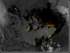
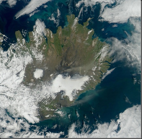
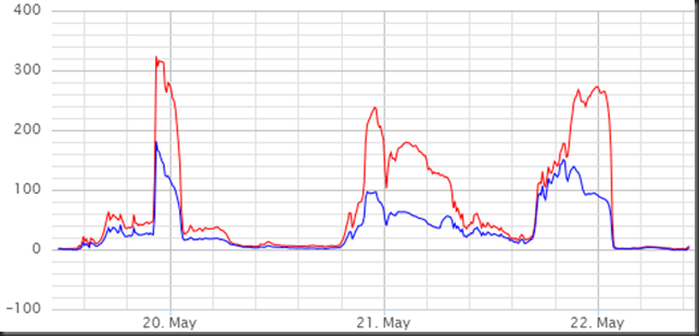
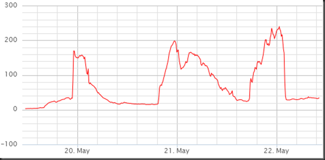
Few pictures, and PM10 data, from ash- and dust storms on 20 May 2012.
Images from NASA/Rapidfire/EOS via IMO.
2012-05-14
Dust storms in cold dry weather and strong winds
Yesterday, today, and probably for the next couple of days, we expect dust storms off the sandur and ash fallout areas in the south of Iceland. There is no rain in forecasts in the south till Friday, and tomorrow the forecast is for a strong northerly wind still (13 m/s), then more SE at 7 m/s on Wednesday, which might be enough.
At noon today the weather map looked like this (en.vedur.is)
Satellite image from 12:20 today shows a dust storm just east of Mýrdalsjökull.
Yesterday, around 15:10 there was also a dust/ash storm visible.
2012-04-29
Small dust storms east of Mýrdalsjökull
Small dust storms are visible east of Mýrdalsjökull, just east of Múlakvísl and Blautakvísl.
At 12 and 13 the weather there was sunny and dry, but a little windy, as can be seen from these maps from the IMO.
No increase in particulate matter at Kirkjubæjarklaustur and Raufarfell; small and very local sources of these dust storms.
2012-04-22
Wildfire in Borgarfirði; 20120421
Farmers used the still weather to burn dead grass and such in Borgarfjord. This is a behavior which the fire chief in Borgarbyggð is not happy about (see interview).
Satellite image from 14:10, Saturday 21 April 2012. (MODIS image from NASA Rapidfire).
The fire was clearly seen, as seen above, by satellites.
The location of the fires according to satellite data is shown on the Google map above. The label for each of the 3 points shows the time stamp and Fire Radiative Power (FRP) in MW.
Einar Svenbjörnsson hefur skemmtilega lýsingu á reykmekkinum á bloggsíðu sinni.
2012-04-05
No ice on Öskjuvatni
No ice cover on lake Öskjuvatni is causing some interest. This is clearly seen on satellite images from NASA on 2 April 2012.
Öskjuvatn is the dark spot just to the north-east of the center of the country. Image from 2 April 2012 (NASA Rapidfire).
There aren’t that many possible explanations. It seems unlikely that weather plays a crucial role, other lakes are ice covered that should experience similar conditions. That leaves increased geothermal activity as the most likely explanation. The lake is 220 m deep, so increase in geothermal activity takes a while to show on the surface.
2012-03-09
New article about ash and health
New article in BMJ open about:
A survey of early health effects of the Eyjafjallajökull 2010 eruption in Iceland: a population-based study
In short the conclusions are:
Short-term ash exposure was associated with upper airway irritation symptoms and exacerbation of pre-existing asthma but did not contribute to serious health problems. The exposure did not impair respiratory function compared to controls. Outdoor use of protective glasses and face masks was considered protective against irritation in eyes and upper airway.
Reference:
Hanne Krage Carlsen, Thorarinn Gislason, Bryndis Benediktsdottir, Thorir Bjorn Kolbeinsson, Arna Hauksdottir, Throstur Thorsteinsson, Haraldur Briem. 2012.
A survey of early health effects of the Eyjafjallajökull 2010 eruption in Iceland: a population-based study.
BMJ Open 2012;2:e000343. doi:10.1136/bmjopen-2011-000343 (Paper on BMJ Open web site)
2012-02-22
Dust storm from Skeiðarársandur
On 18 February 2012 there was a clear dust storm stemming from the sandur, Skeiðarársandur, south of Skeiðarárjökull, outlet of Vatnajökull, Iceland.
Satellite image (MODIS) from 13:00 show the dust storm very clearly.
Image courtesy of NASA/GSFC, Rapid Response.
The wind speed (10-min average) was quite high around noon.
The wind speed reaches around 15 m/s around noon at the station Kirkjubæjarklaustur – Stjórnarsandur, see location on the image below.
2012-01-19
New article about ash during Eyjafjallajökull eruption
High levels of particulate matter in Iceland due to direct ash emissions by the Eyjafjallajökull eruption and resuspension of deposited ash
Throstur Thorsteinsson
Environment and Natural Resources and Institute of Earth Sciences, University of Iceland, Reykjavík, Iceland
Thorsteinn Jóhannsson
The Environment Agency of Iceland, Reykjavík, Iceland
Andreas Stohl and Nina I. Kristiansen
Norwegian Institute for Air Research, Kjeller, Norway
JOURNAL OF GEOPHYSICAL RESEARCH, VOL. 117, B00C05, 9 PP., 2012
Citation: Thorsteinsson, T., T. Jóhannsson, A. Stohl, and N. I. Kristiansen (2012), High levels of particulate matter in Iceland due to direct ash emissions by the Eyjafjallajökull eruption and resuspension of deposited ash, J. Geophys. Res., 117, B00C05, doi:10.1029/2011JB008756.
Abstract
The dangers to people living near a volcano due to lava and pyroclastic flows, and, on glacier- or snow-covered volcanoes, jökulhlaups, are well known. The level of risk to human health due to high concentrations of ash from direct emission and resuspension from the ground is, however, not as well known. The eruption at Eyjafjallajökull, 14 April to 20 May 2010, produced abundant particulate matter due to its explosive eruption style. Even after the volcanic activity ceased, high particulate matter (PM) concentrations were still measured on several occasions, due to resuspended ash. The 24 hour mean concentration of PM10 in the small town of Vík, 38 km SE of the volcano, reached 1230 μg m−3, which is about 25 times the health limit, on 7 May 2010, with 10 min average values over 13,000 μg m−3. Even after the eruption ceased, values as high as 8000 μg m−3 (10 min), and 900 μg m−3 (24 h), were measured because of resuspension of freshly deposited fine ash. In Reykjavík, 125 km WNW of the volcano, the PM10concentration reached over 2000 μg m−3 (10 min) during an ash storm on 4 June 2010, which should have warranted airport closure. Summarizing, our study reveals the importance of ash resuspension compared to direct volcanic ash emissions. This likely has implications for air quality but could also have detrimental effects on the quality of ash dispersion model predictions, which so far generally do not include this secondary source of volcanic ash.
For a copy, please send me an e-mail.
2012-01-04
Particulate matter pollution during New Year’s Eve 2011/12
The concentration of PM10 reached (at GRE) 1230 micro-g/m3; average during the 30-minutes from midnight till 12:30 on 1 January 2012.
Precipitation and slow wind made sure that the peak did not last long this year.


