In Fljótshverfi, in the east, the PM10 has been quite high at times due to the strong winds and dry weather.
High concentration in Reykjavik also, due to previous doses of ash from the east, and traffic, as seen from GRE data for PM10.
In Fljótshverfi, in the east, the PM10 has been quite high at times due to the strong winds and dry weather.
High concentration in Reykjavik also, due to previous doses of ash from the east, and traffic, as seen from GRE data for PM10.
Today, 17 March 2013, there is a lot of dust and ash blowing to the south from the south coast of Iceland.
Black numbers are wind speed in meters per second (blue numbers temperature in °C). Image from the IMO.
Yesterday, and today (7 March 2013), we have had some snowfall here in Reykjavik. Usually isn’t really a news, although snowfall has been rather rare this winter. However, what is kind of interesting is that the snow is quite far from being white.
The snow is more towards brownish, as seen (hopefully) from the figure below. Mind you, this car has not been moved since the snowfall started, and this is the color on the ground and everywhere.
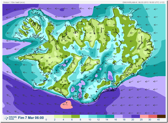
The most likely explanation is that the snow is mixed with ash and dust from the east. There has been a relatively strong easterly wind, and blowing ash and dust has been reported in the area east of Eyjafjallajökull (Eyjafjöllum, Mýrdal, Fljótshlíð, Öræfasveit, Kirkjubæjarklaustur, and other places).
Wind has been from the area, as seen on this map from this morning from IMO.

The particulate matter, PM10, was quite high on 4 March 2013 due to dry northerly winds. The highest 30 min concentration was 372 µg/m3 at 20:00. The 24-hour average was 80 µg/m3, above the health limit of 50 µg/m3.
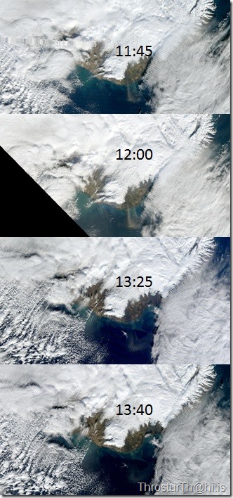
There were also dust storms as clearly seen on the satellite images below. Fun to follow the plume between 11:25 to13:40 (images courtesy of NASA/Rapidfire and IMO).
