Addition to http://envnatres.wordpress.com/2013/11/13/earlier-bird-migration/
2013-11-13
Earlier bird migration
An interesting study by University of East Anglia (and University of Iceland, Tomas G Gunnarsson) found that individual (adult) birds are not migrating earlier, rather, since they nest earlier, the young birds migrate earlier.
So warming climate is allowing the birds to nest and hatching earlier, which results in those younger birds arriving earlier – but apparently, each individual bird will stick to a fixed date for migration.
Or, as it says in the news item:
We found that birds hatched in the late 1990s arrived in May, but those hatched in more recent years are tending to arrive in April. So the arrival dates are advancing because the new youngsters are migrating earlier.
This was found by studying the Icelandic black-tailed godwits over 20 years.

About this study on Eurekalert.com.
2013-11-08
Small dust storm visible from the SA of Iceland
2013-11-02
Particulate matter in Reykjavik and Hafnarfjörður on 1 Nov 2013
Relatively high levels of particulate matter were measured in Reykjavik and Hafnarfjörður on 1 November 2013. The situation was unusually complicated, low wind, some dust storm seen and a burning ship in Hafnarfjörður.
Let's start with a satellite taken at around 13 on 1 Nov. A clear dust storm is seen blowing off the Reykjanes peninsula. There also seems to be a dust cover in Reykjavik, but cloud cover makes it impossible to distinguish, and the source area is hidden.
Satellite image taken at 13:10 on 1 November. Image courtesy of MODIS/Rapidfire.
It is not obvious where the source area is?
The wind direction in Reykjavik was northerly, like can be seen from the data from IMO below. The wind speed increased around noon, but still not very strong winds.
Due to the northerly wind direction, the most likely source areas, if there was a dust storm, are south of Langjökull.
There were high levels of PM in Reykjavik and Hafnarfjörður, and since they are similar it might be a dust storm.
Measurements of PM at Grensásvegur on 1 Nov.
Traffic seem to be the most likely reason for the high levels of PM in the morning, and possibly for the whole day. There might also be a contribution from dust storm …
NOx reaches high levels in the morning, therefore likely traffic in the morning. However, not very high in the afternoon, so possibly something else, such as dust storm.
Measurements of PM form Hvaleyrarholt, Hafnarfjörður, 1 November.
In the morning, and possibly also just after noon, it was the burning of the ship Fernando which caused the high levels of PM. Also might be a dust storm contribution in afternoon.

The Icelandic coast guard ship, Thor, putting out the fire. mbl.is/Júlíus Sigurjónsson (fréttin).
2013-09-17
Dust storm on 17 September 2013
Still strong northerly winds and dust blowing from the sandur areas on the south coast of Iceland; from Landeyjasandur and nearby, Mýrdalssandur, Meðallandsfjöru and nearby.
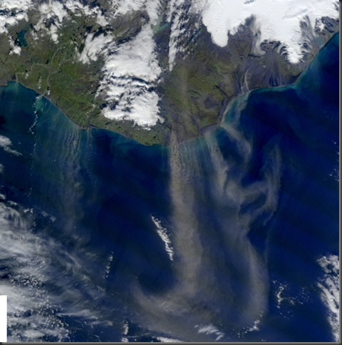
Image from 13:40. Image from NASA/Rapidfire via IMO.
Windspeed at Skarðsfjöruviti (a) was 10 – 11 m/s, with gusts up to 15 m/s. At Kirkjubæjarklaustrur (b) the wind speed was 13 – 15 m/s, but gusts up to 25 m/s.
2013-09-16
Dust storm on 16 September 2013
A low south-east of Iceland caused strong winds, which in turn caused dust storms from the south coast, from Mýrdalssandur and Meðallandsfjörur.
Average wind speed at Skarðsfjöruviti around noon, when satellite images taken (13:00 below), was between 14 – 16 m/s, with gusts up to 21 m/s.
2013-09-02
Dust storm from sandur area north of Dyngjujökull
Quite a big dust storm originated from Holuhraun, north of Dynjujökull, outlet glacier of Vatnajökull, in Iceland today. At the time the satellite image was taken, around 14:40 on 2 September 2013, the wind speed at the nearby weather station Kárahnjúkar showed wind speeds of 18 m/s, with gusts up to 24 m/s.
2013-07-19
PM10 concentration in Reykjavík 2008 – 2012.
PM10 concentration in Reykjavík 2008 – 2012.
2013-05-22
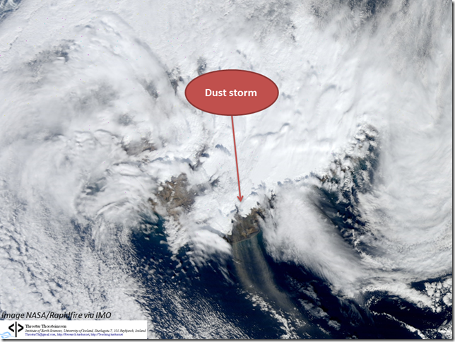
Dust storm to the sea 22 May 2013
Sunny and windy, thus dust storms on the south coast of Iceland.
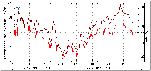
At Skarðsfjöruviti
(green dot) the wind has been quite strong, over 10 m/s around noon
(data from vedur.is).
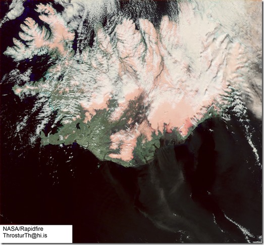
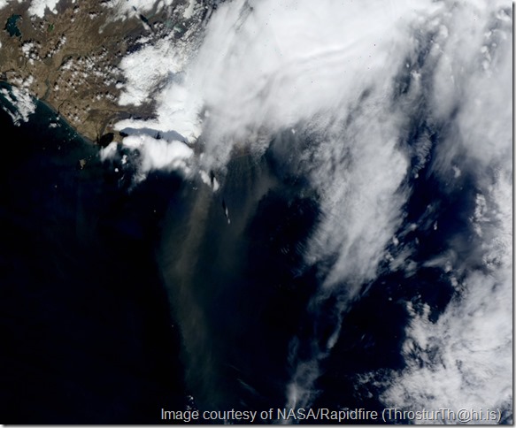
Satellite images show the dust storm nicely, around 13:50
This is a mix of bands – so false colors. The natural colors are below.
2013-05-17
Dust storm and peaks in PM10 in Reykjavik on 16 May
Clearly visible dust storm from the South of Iceland around 13 on 16 May 2013.
The PM10 concentration in Reykjavik (GRE station) also peaked, but the source is a little unclear. The wind direction is northerly, and the wind is not very great (around 5 m/s). Traffic contributes, but why this relatively large peak, almost 250 µg/m3 ?
2013-05-15
Poster at the Final Ice2sea Open Forum
University of Iceland was a partner in the EU project Ice2sea. Amongst results is a better constrain on potential sea level rise. Our contribution was regarding sliding of glaciers, as explained on the poster below.
We have developed a method where the changes in water flux reaching the bed determine the efficiency of the water system to transport water. In very short terms, sudden pulses of water have greater effect on the sliding velocity than “normal” variations, such as diurnal variation during summer.
Dust and ash blowing out to sea
Today, 14 May 2013, there was quite a bit of dust and ash blowing out to sea. The conditions were prime, sunny and windy, as can be seen from the wind velocity at Þykkvabær, where the average wind speed was over 15 m/s before noon today.
Satellite images taken at 11:50, 12:10, 13:30 and 13:45, show how the dust and most likely ash (although the distinction can be difficult now) was being blown out to sea by the northerly winds.
11:50
12:10
13:30
13:45
2013-04-28
Dust storm on 28 April 2013
Strong northerly winds, over 15 m/s, and dry weather, equal dust storm.
Winds at Stórhöfði, Vestmannaeyjar today from IMO.
Zoom in, image from 11:50
Another zoom from 12:10
2013-04-15
Dust and ash storm 15 April 2013
High winds, for instance, NW to N winds at 18 – 19 m/s at Höfn, Hornarfirði, between 12 and 15 today. Dust- and ash storm, especially in the SA. Fun to see the time evolution on satellite images from 12:20, 12:40 and 14:00 today.
Images courtesy of NASA/Rapidfire.
Lots of Particulate Matter 14 April 2013
High levels of PM10 measured in Reykjavik, and in Fljótshverfi in the east.
Reykjavík fist, 24-h average about 89.4 µg/m3. Wind not terribly strong, but more wind close by which may have contributed.
In Fljótshverfi very high values !
Fljótshverfi location is shown on the map below (green label beneath Vatnajökull).
Clearly dust and ash blowing around in places, as seen in this satellite image from 13:15 on 14 April 2013. Fljótshverfi partially blocked by light cloud cover unfortunately, but second image below shows how it looked.
Fljótshverfi and surroundings 14 April 2013.
2013-04-11
Particulate matter, dust storm and possibly a wildfire
There were many things occurring on Wednesday 10 April 2013.
PM10 was over the health limit in Reykjavik, small dust storm in the south, and possibly also a wildfire. Let’s take a closer look
PM10 was over the limit in Reykjavik, at the station Grensás.
The 24-h average was ~58.6 µg/m3, but the health limit is 50 µg/m3. Wind speed was less than 5 m/s and, even though NOx isn’t very high, this is most likely connected to traffic.
It was possible to detect a small dust storm, most likely, on a MODIS image, Terra satellite.
(Image courtesy of NASA/Rapidfire)
Then there was a satellite detection of a thermal anomaly, a wildfire. These can be false, and I haven’t seen anything in the news to verify this – if you know whether there was a fire or not, please let me know. This was around 14:00 on 10 April 2013, the location is shown on the figure below.
On a satellite image, taken at 14:00, it is possible to detect what might be smoke from a wildfire ?
2013-03-18
Dust/ash storm 18 March 2013
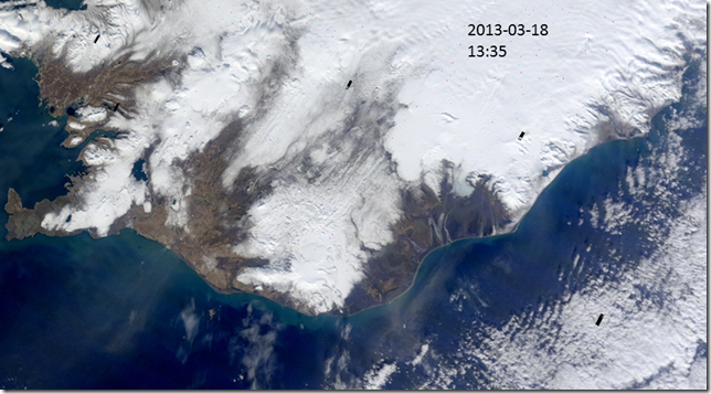
In Fljótshverfi, in the east, the PM10 has been quite high at times due to the strong winds and dry weather.
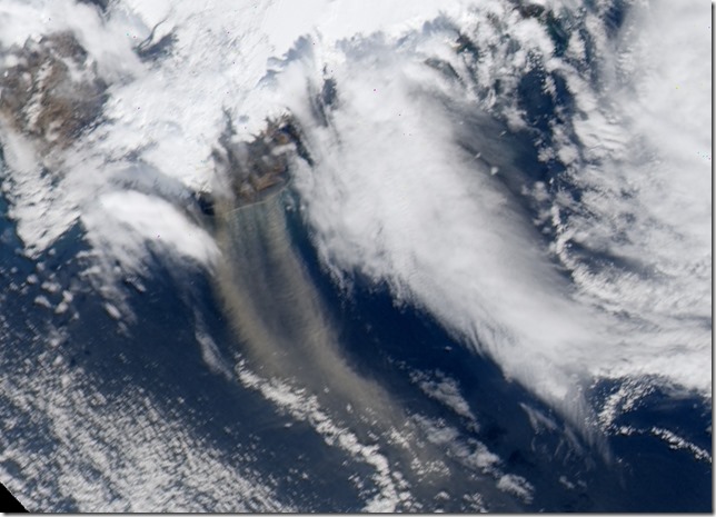
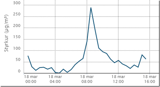
High concentration in Reykjavik also, due to previous doses of ash from the east, and traffic, as seen from GRE data for PM10.


