2011-05-25

Eruption very much reduced, end near, but lot of ash to deal with

It seems that the eruption in Grímsvötn is quickly winding down.

Plenty of ash to deal with though !

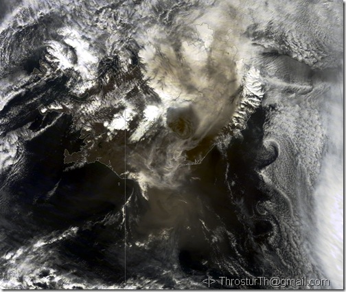
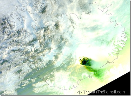
Couple of satellite images, from NASA MODIS sensors, from 23 and 24 May 2011.

20110523_1205_modis_A20111431205_crop

23 May 2011. A lot of ash, probably mostly windblown but hard to tell exactly.

20110524_1440_modis_P20111441440_crop

24 May 2011. A little better, in terms of actually seeing down to the land surface, and less material being emitted and/or blown.

2011-05-22

Ash from Grímsvötn eruption reaches Reykjavik

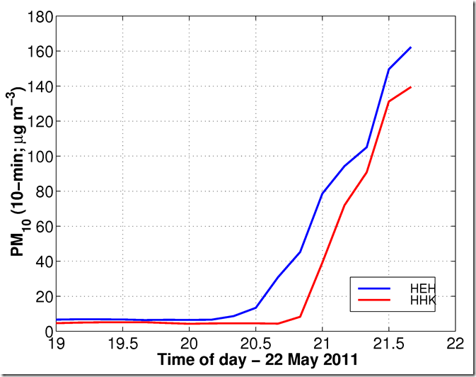
Measurements in the great Reykjavik area, at Hvaleyrarholti and Digranesheiði, show clearly that as from the eruption in Grímsvötn has reached Reykjavik. Around 20:30 on 22 May 2011.

PM10_HEH_HHKDigranes_22May2011 

Latest measurements indicate that this was about the top values, this time around, with concentration much lower now at 22:00, and high value of 194 micro-g/m3 at HEH.

Of course we can expect other peaks like this, even later tonight.

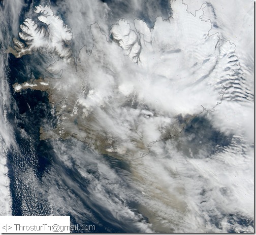
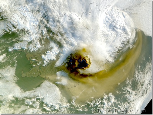
Even more sat-photos from the eruption today, 22 May 2011

20110522_crefl1_1300_crop

At 13:00 today, 22 May 2011 (NASA MODIS/Rapidfire).

More satellite images from the Grímsvötn eruption

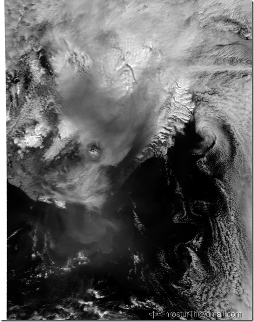
201105221126_EV_250_RefSB_b

Today at 11:26; 22 May 2011  (MODIS/NASA/RAPIDFIRE – EV).

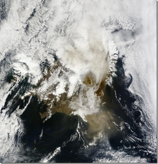
201105221304_rgb_crop

Today at 13:04 (MODIS/NASA/Rapidfire).

Eruption in Grímsvötn, Vatnajökull, Iceland

Eruption has started in Grímsvötn, Vatnajökull, Iceland.

Big plume, and some ash fall. Can expect jökulhlaup, probably not very large, but depends on the size of the eruption site.

20110521_2200_modis_A20111412200

Image from 21 May 2011, at 22:00 (NASA/MODIS, from IMO).

20110522_0510_modis_P20111420510

Image from 22 May 2011, at 05:10 (NASA/MODIS, from IMO).

2011-05-18

Pictures from Glaciology field trip 2011

2011 Glaciology Field Trip

A few pictures, including:

  • Gígjökull – drastic changes since the Eyjafjallajökull eruption
  • Sólheimajökli – always big changes between years, retreating fast
  • Reynisfjöru – columnar lava, …

2011-05-11

Article in Atmospheric Chemistry and Physics about ash emission during the Eyjafjallajökull eruption 2010

Determination of time- and height-resolved volcanic ash emissions and their use for quantitative ash dispersion modeling: the 2010 Eyjafjallajökull eruption 

A. Stohl1, A. J. Prata1, S. Eckhardt1, L. Clarisse2, A. Durant1,3,4, S. Henne5, N. I. Kristiansen1, A. Minikin6, U. Schumann6, P. Seibert7, K. Stebel1, H. E. Thomas4, T. Thorsteinsson8, K. Tørseth1, and B. Weinzierl6

1
Norwegian Institute for Air Research (NILU), Kjeller, Norway, 2Spectroscopie de l'Atmosphére, Service de Chimie Quantique et Photophysique, Université Libre de Bruxelles, Brussels, Belgium, 3Centre for Atmospheric Science, Department of Chemistry, University of Cambridge, Lensfield Road, Cambridge, UK, 4Department of Geological Engineering and Sciences, Michigan Technological University, Houghton, MI, USA, 5Empa, Swiss Federal Laboratories for Materials Science and Technology, Dübendorf, Switzerland, 6Deutsches Zentrum für Luft- und Raumfahrt, Institut für Physik der Atmosphäre, Oberpfaffenhofen, Germany, 7Institute of Meteorology, University of Natural Resources and Life Sciences, Vienna, Austria, 8Institute of Earth Sciences, University of Iceland, Reykjavik, Iceland


Abstract. The April–May, 2010 volcanic eruptions of Eyjafjallajökull, Iceland caused significant economic and social disruption in Europe whilst state of the art measurements and ash dispersion forecasts were heavily criticized by the aviation industry. Here we demonstrate for the first time that large improvements can be made in quantitative predictions of the fate of volcanic ash emissions, by using an inversion scheme that couples a priori source information and the output of a Lagrangian dispersion model with satellite data to estimate the volcanic ash source strength as a function of altitude and time. From the inversion, we obtain a total fine ash emission of the eruption of 8.3 ± 4.2 Tg for particles in the size range of 2.8–28 μm diameter. We evaluate the results of our model results with a posteriori ash emissions using independent ground-based, airborne and space-borne measurements both in case studies and statistically. Subsequently, we estimate the area over Europe affected by volcanic ash above certain concentration thresholds relevant for the aviation industry. We find that during three episodes in April and May, volcanic ash concentrations at some altitude in the atmosphere exceeded the limits for the "Normal" flying zone in up to 14 % (6–16 %), 2 % (1–3 %) and 7 % (4–11 %), respectively, of the European area. For a limit of 2 mg m−3 only two episodes with fractions of 1.5 % (0.2–2.8 %) and 0.9 % (0.1–1.6 %) occurred, while the current "No-Fly" zone criterion of 4 mg m−3 was rarely exceeded. Our results have important ramifications for determining air space closures and for real-time quantitative estimations of ash concentrations. Furthermore, the general nature of our method yields better constraints on the distribution and fate of volcanic ash in the Earth system.

Paper (PDF, 2220 KB)


Citation: Stohl, A., Prata, A. J., Eckhardt, S., Clarisse, L., Durant, A., Henne, S., Kristiansen, N. I., Minikin, A., Schumann, U., Seibert, P., Stebel, K., Thomas, H. E., Thorsteinsson, T., Tørseth, K., and Weinzierl, B.: Determination of time- and height-resolved volcanic ash emissions and their use for quantitative ash dispersion modeling: the 2010 Eyjafjallajökull eruption, Atmos. Chem. Phys., 11, 4333-4351, doi:10.5194/acp-11-4333-2011, 2011.  

Link for the paper: http://www.atmos-chem-phys.net/11/4333/2011/acp-11-4333-2011.html
2011-05-07

Article in Icelandic about bank erosion and evolution at Blöndulón reservoir, N-Iceland

This article deals with wave erosion and evolution of the banks of the man-made reservoir lake, Blöndulón.

The bank evolution has been monitored quite closely since formation of the lake.

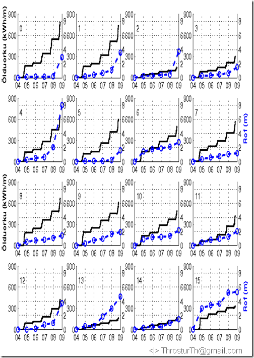
Calculations of the wave power are compared to erosion rates. Complicated relationship, different types of banks, episodic events, and relatively short time series 1997 to 2010.

But, as seen in the figure below, it is possible to see some correlation.

CumWavePower_Erosion

“Ölduorka” – Wave power (kWh/m), and “Rof” – Erosion (m).

Reference:

Olga Kolbrún Vilmundardóttir, Þröstur Þorsteinsson, Borgþór Magnússon og Guðrún Gísladóttir. 2011.
Landbrot og mótun strandar við Blöndulón.
Náttúrufræðingurinn, 81(1): 17 - 30.

For a paper with more details about the theory, see:

O. K. Vilmundardóttir, B. Magnússon, G. Gísladóttir, Th. Thorsteinsson.  2010.
Shoreline erosion and aeolian deposition along a recently formed hydro-electric reservoir, Blöndulón, Iceland.
Geomorphology, 114(4): 542 - 555.

2011-05-02

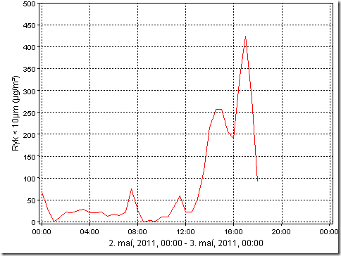
Particulate matter in Reykjavik 2011-05-02

Rather high values of PM10 now in Reykjavik.

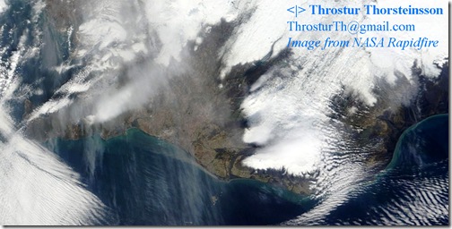
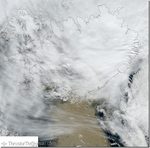
The reason, as seen in the image below, is partly due to dust storms from Landeyjasandur (just north of Vestmannaeyjar).

Iceland_20110502_ThrosturTh

Measurement at Grensás, in Reykjavik, show that the PM10 concentration reached just over 400 micro-grams per cubic meter just after 16:00.

GRE_PM10_20110502