2016-03-02

Air quality index, loftvís

To estimate air quality, or figure out the current conditions, one needs to know the different units of measure, µg/m3, or mg/m3, and the different health limits for the different pollutants. Also, short term pollution limits are not the same as 24-hour health limits.
Examples of available data are measurements of PM10:
NO2:
and H2S:
It is possible to show these in a simpler way, using an index that accounts for the health limits. Thus, a value of 1 for the index, I, means that one of the pollutants has reached it’s limit. Higher values than 1 mean that they have been exceeded, and lower values than 1 mean that the air quality is better. Below is an example for the past week:

It is clear that the air quality has been rather good lately. If we look at the whole year, we see that on 10-11 January the 24-hour health limit was exceeded (here using a running 24-hour mean), and that it was due to PM10.


We can also show more current conditions this way. Several pollutants do though not have public health limits for shorter periods than 24-hours. Also, using hourly values would lead to very rapidly fluctuating values, since short peaks (real and in the data) complicate things. Therefore I show 4-hour averages, which give good indication about the current conditions (using 50 µg/m3 for PM10 and H2S, but 110 µg/m3 for NO2, is 75 for 24-hours).

2015-11-20

Dust blowing in SE-Iceland

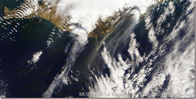
Dry weather and strong winds are causing sediment from glacier rivers to blow in the SE of Iceland 19 and 20 November 2015. There was a recent jökulhlaup from Skaftárkatlar (material blown in the center of the images below).

Wind speed at Skarðsfjöruviti shows that the wind speed, gusts, exceeded 10 m/s around noon on the 19 November.

Below are MODIS and Landsat images from around 13:50 on 19 November.

20151119_1350_modis_crop
MODIS image from 13:50 on 19 November 2015 (Image courtesy of NASA/Rapidfire).

20151119_LC8_crop_b
Landsat 8 image 19 November 2015 (Landsat 8 image from NASA and USGS). 

Reykjavík has also been dry and windy, and the PM10 concentration relatively high; up to 200 µg/m3 30-min averages on 18 November 2015.

2015-10-19

Dust storm north of Vatnajökull 17 October 2015

Large dust storm from just north of Dyngjujökull, outlet glacier of Vatnajökull, Iceland.

Good weather conditions (for dust storm), windy, dry and sunny. Gusts over 20 m/s, and 10 min wind around 15 m/s.

20151017_Upptyppingar_f_1v

Data from Upptyppingar, IMO weather station.

Satellite image taken at 12:55 on 17 October 2015.

20151017_modis_zoom

2015-05-01

Dust storm(s) 26 and 28 April 2015

Sunny and dry in the south these days, and a bit windy at times. Prime conditions for dust storms.

On 26 April 2015 there were several source areas.

20150426_Iceland2.2015116.terra_zoom

On 28 April 2015 there were several source areas visible also, from Ölfus to Jökulsárlón.

20150428_Iceland2.2015118.terra_zoom

Note that it looks like there are two wind direction governing the dust east of Mýrdalsjökull; small stroke due south, and other ones to the south-west.

20150428_1700_Vedur_SA_IMO

This figure shows the meteorological observations in the area at 17:00 on the 28 May 2015. Looks like different wind direction at nearby location is not unlikely.

2015-02-03

Holuhraun

Holuhraun eruption still going, since 31 August 2014. The lava is now 1.3 km3, and covers over 80 km2. There is a lot of SO2 gas coming with the eruption, leading to pollution events where the concentration is well above the health limits.


Image from 31 January 2015, at 12:20 (Modis image from NASA/Rapidfire).