2012-06-10

Ash- and dust storms

The last couple of days there has been a lot of Particulate Matter (PM) in the east, and also in the Reykjavik area. This is clear from recent headlines: “Ekki hægt að fara út fyrir svifryki (Not possible to be outside because of PM)” og “Velti bíl í ösku á Skeiðarársandi (Car overturns as it drives into a ash on the road)”.

In Fljótshverfi (south of Vatnajökull, see map) the concentration increased rapidly on 8 June, and was over 100 micro-g per cubic meter around 10, and was very high , over 1000 micro-g  per cubic meter around 17:00, but then decreased after that. Stations in Reykjavik showed the ash arriving later in the evening, around 20:30.

On 9 June there were high levels of PM in the Reykjavik area, both due to the ash from east, and also possibly from a dust storm from Landeyjasandur (see image).

The image should be a little bigger if clicked on Smile

20120608_10_Svifryk

2012-05-29

Still some ash and dust blowing around

Yesterday, 28 May 2012 a satellite image showed a dust storm originating north of Dyngjujökull, near Jökulsá á Fjöllum. Whether this event, or the sum of many before it, the northern part of Vatnjökull is visibly brownish in the area near this source of dust storms.
20120528_modis_1250_crop
Image from 12:50 Monday 28 May 2012 (NASA/Rapidfire).
Today in Fljótshverfi, east of Kirkjubæjarklaustur (underneath western part of Vatnajökull), PM10 went well over 50 micro-g/m3, up to, and over, 150 micro-g/m3.
Capture
The forecast is for sunny, dry, days, so we can expect more of this if winds pick up – and not by that much.

2012-05-22

High concentration of Particulate Matter around midnight past few days in Reykjavik due to ash re-suspension and dust storms

There has been a lot of ash and dust blowing around the southern part of Iceland the past few days. Sunny and dry, and not much wind needed to re-suspend the ash for instance.

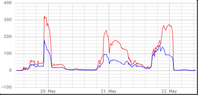
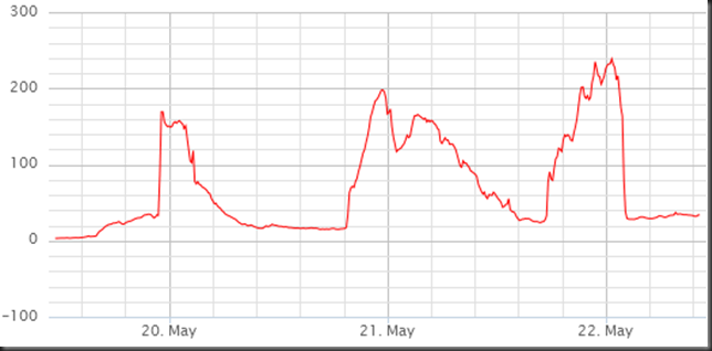
Mainly in the evening that we have had high PM10 concentration here in Reykjavik area. This can be clearly seen from measurements at Grensásvegur, Kópavogur and Hvaleyrarholt.

In the south, at Raufarfell, there was a lot of PM10 mid-day 21 May 2012.

GRE_19_22_may_2012_PM10_capture 
Grensás.

HHK_20_22_may_2012_PM10_PM25_capture 
Kópavogur (HHK).

Hvaleyrarholt_20_22_may_2012_PM10_capture 
Hvaleyrarholt.

Raufarfell_21_may_2012_PM10_capture 
Raufarfell, south of Eyjafjallajökull.

2012-05-20

Ash re-suspension and dust storm on 20 May 2012

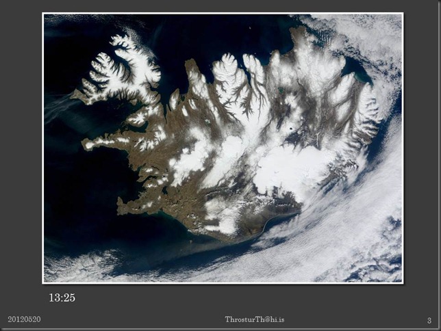
Few pictures, and PM10 data, from ash- and dust storms on 20 May 2012.

Slide1

Slide2

Slide3

Slide4

Images from NASA/Rapidfire/EOS via IMO.