2013-05-15

Dust and ash blowing out to sea

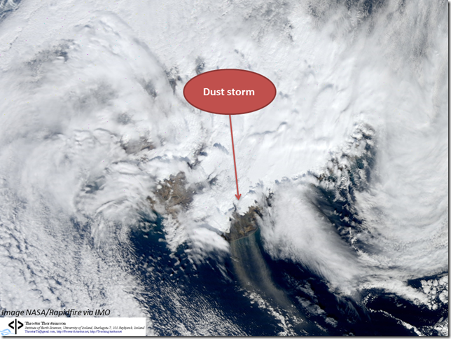
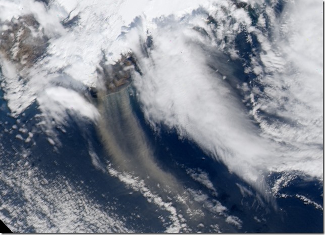
Today, 14 May 2013, there was quite a bit of dust and ash blowing out to sea. The conditions were prime, sunny and windy, as can be seen from the wind velocity at Þykkvabær, where the average wind speed was over 15 m/s before noon today.

image

Satellite images taken at 11:50, 12:10, 13:30 and 13:45, show how the dust and most likely ash (although the distinction can be difficult now) was being blown out to sea by the northerly winds.

11:5020130514_modis_truecol_A20131341150_crop

12:10
20130514_modis_truecol_P20131341210_crop

13:30

20130514_modis_truecol_A20131341330_crop

13:45

20130514_modis_truecol_P20131341345_crop

2013-04-28

Dust storm on 28 April 2013

Strong northerly winds, over 15 m/s, and dry weather, equal dust storm.

image

Winds at Stórhöfði, Vestmannaeyjar today from IMO.

20130428_overview

Zoom in, image from 11:50

20130428_modis_truecol_A20131181150_crop

Another zoom from 12:10

20130428_modis_truecol_P20131181210

2013-04-15

Dust and ash storm 15 April 2013

High winds, for instance, NW to N winds at 18 – 19 m/s at Höfn, Hornarfirði, between 12 and 15 today. Dust- and ash storm, especially in the SA. Fun to see the time evolution on satellite images from 12:20, 12:40 and 14:00 today.

20130415_modis_truecol_A2013105122020130415_modis_truecol_P2013105124020130415_modis_truecol_A20131051400

Images courtesy of NASA/Rapidfire.

Lots of Particulate Matter 14 April 2013

High levels of PM10 measured in Reykjavik, and in Fljótshverfi in the east.

Reykjavík fist, 24-h average about 89.4 µg/m3. Wind not terribly strong, but more wind close by which may have contributed.

image

In Fljótshverfi very high values !

image

Fljótshverfi location is shown on the map below (green label beneath Vatnajökull).

image

Clearly dust and ash blowing around in places, as seen in this satellite image from 13:15 on 14 April 2013. Fljótshverfi partially blocked by light cloud cover unfortunately, but second image below shows how it looked.

image

image

Fljótshverfi and surroundings 14 April 2013.

2013-04-11

Particulate matter, dust storm and possibly a wildfire

There were many things occurring on Wednesday 10 April 2013.

PM10 was over the health limit in Reykjavik, small dust storm in the south, and possibly also a wildfire. Let’s take a closer look Bros

PM10 was over the limit in Reykjavik, at the station Grensás.

image

The 24-h average was ~58.6 µg/m3, but the health limit is 50 µg/m3. Wind speed was less than 5 m/s and, even though NOx isn’t very high, this is most likely connected to traffic.

It was possible to detect a small dust storm, most likely, on a MODIS image, Terra satellite.

20130410_modis_worldview_crop
(Image courtesy of NASA/Rapidfire)

Then there was a satellite detection of a thermal anomaly, a wildfire. These can be false, and I haven’t seen anything in the news to verify this – if you know whether there was a fire or not, please let me know. This was around 14:00 on 10 April 2013, the location is shown on the figure below.

image
Map from ja.is.

On a satellite image, taken at 14:00, it is possible to detect what might be smoke from a wildfire ?

image
Image courtesy of NASA/Rapidfire.