2010-04-26

Particle size of the ash

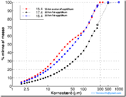
Measurements, made at Nýsköpunarmiðstöð Íslands, show, as was to be expected, that the particle size is greater closer to the eruption site.

However, one (18.4) of the two samples taken 20 km away, is very similar to the one taken nearly 60 km away (15.4).

kornaminna_15_17_18_april

The sample collected on 15.4 by Sigurður Reynir Gíslason and on the 17 and 18. 4 by Guðrún Larsen and Ármanni Höskuldssyni.

kornaminnaflokkagna_15_17_18_april

2010-04-25

SO2 and ash

Below is a map of the distribution of SO2 from 23 April 2010.

I also post the picture I used to tell the distribution of small particles on the 23rd – pretty good match.

iceland_so2lf_5k_20100423

20100423_btd_1240

Image taken 12:40 on 23 April 2010.

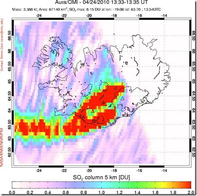
Here is then the distribution of SO2 from yesterday, 24 April 2010.

iceland_so2lf_5k_20100424

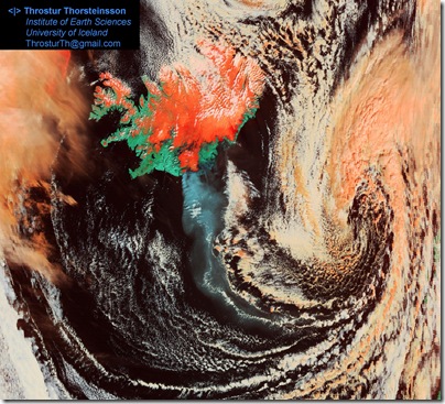
 20100424_modis_1305

And the true color image from 24 April 2010, at 13:05.

2010-04-24

Eyjafjallajokull eruption 24 April 2010

Not much action visible, nor reported, in the eruption at Eyjafjallajokull.

A bit of ash falling in areas getting ever closer to Reykjavik, but in very small, trace, amounts.

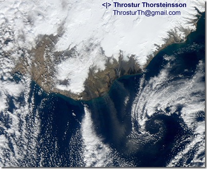
Some if it is most likely re-suspended ash, and dust storm, as can be seen from the image below from 11:42 today, 24 April 2010.

20100424_MER_114206_zoom

In all likelihood my interpretation of the ash plume yesterday was correct, judging from reports of ash fall.

2010-04-23

Eruption plume getting closer to Reykjavik?

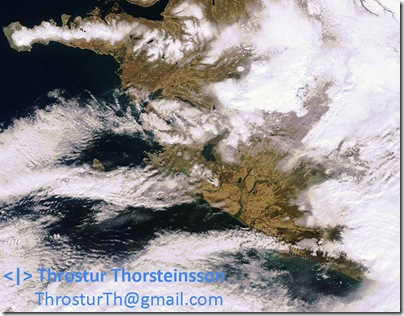
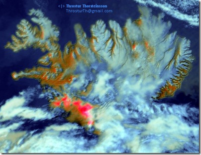
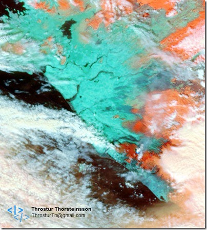
The following satellite images, from 12:20 and 12:40 today, 23 April 2010, show, at least I think they do, that the eruption plume (ash) has travelled north and then west from the eruption site at Eyjafjallajokull.

If this is correct, the plume is quite close to Reykjavik, but still not all the way. Nothing to worry I would think, not much being emitted by the volcano now, and the plume has travelled quite far.

I do also stress that this is just my speculation right now !

If someone can provide further evidence, for or against this interpretation, please let me know !
20100423_MER_122054_zoom2

Difficult to see on this true color image from 12:20, but with some effort it is possible to see the plume traveling north from the eruption site, and then (even more difficult to see) turning west.
20100423_btd_1240

This image, I think, shows the eruption plume (ash) as the red color (at least this is what we designed this image to detect). If correct, the plume travels north and then west, almost reaching Reykjavik area, but not quite.

I am not absolutely sure about this interpretation, so any evidence for or against would be greatly appreciated.
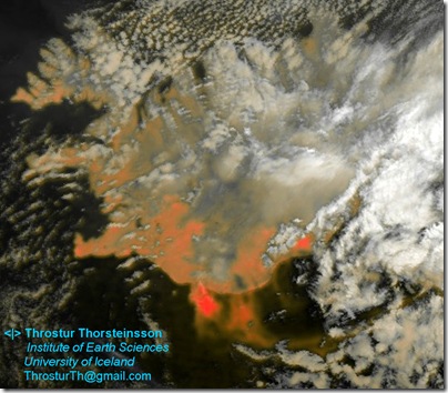
 20100423_Iceland_367_zoom

This false color image shows the plume quite nicely heading north and then turning west – as it sort of merges with clouds (present at that time).
Eruption today 23 April 2010

Satellite image from 12:20 today, 23 April 2010. Small plume, appears to be mostly steam.

MER_FR__0PNPDE20100423_122054_000002572088_00453_42591_6642.N1_4BD19600_preview 20100423_MER_122054_zoom

2010-04-21

Eyjafjallajökull 21 April 2010

Relatively slow day, not even dust blowing just before noon.

Satellite images taken at 11:36 on 21 April 2010.

20100421_MER_113630

20100421_MER_1136

2010-04-20

Satellite images 20 April 2010

Images taken at 12:09 and 12:15 today, 20 April 2010.

20100420_MER_1209

20100420_MER_1209_zoom

20100420_MER_1215

Eruption and blowing ash

Eruption still ongoing, although with changed behavior as a small mountain is blocking off parts of the water, and lava was seen for the first time yesterday.

20100420_btd_0410

This image, taken at 04:10 on 20 April 2010, shown the eruption plume, and for the first time a hot spot (black dot) for the eruption site. A lot of dust/ash is blowing out to sea east of the eruption site.

2010-04-19

More eruption stuff – ash plume

The ash plume reaches far out to sea today, as can be seen from the figures below.

20100419_crefl1_367_1250_20101091255

This one is from 12:50 on 19 April 2010.

20100419_IcelandCrop_367Zoom in, notice the dust storm also. 

Eruption plume and dust storms

Clear skies and sunny in the south of Iceland today. Quite windy also, from the north.

The eruption plume is clearly visible, as well as several dust storms on the southern coast sandur planes.

20100419_MER_124048

This images was taken at 12:41 today 19 April 2010.

Eruption plume at 05:05 on 20100419

Quick update of the eruption plume, brightness temperature difference image from 05:05 on the 19 April 2010 – compare to the one from 03:25 in the previous post.

20100419_btd_0505

Eruption plume last night 20100419

According to local news there was considerable ash fall south of the eruption site at Eyjafjallajökull last night.

Below is the headline:

Innlent | mbl.is | 19.4.2010 | 07:00
Talsvert öskufall frá Ásólfsskála að Sólheimajökli (Considerable ash fall from Ásólfsskála to Sólheimajökull)

This fits very nicely with satellite data from last night, image taken at 03:25 on 19 apríl 2010.

20100419_btd_P20101090325

This brightness temperature image shows clearly the ash (and possibly steam) plume emanating from Eyjafjallajökull.

The use and development of the brightness temperature images is something I am currently working on with the Icelandic Met Office.

2010-04-18

Eruption at Eyjafjallajokull 17 and 18 April 2010

Nice satellite images from the 17 April 2010, and temperature difference on the 18 April 2010.

20100417_MER_120925

17 April 2010, at 12:09 – image from MERIS.

20100417_MER_120243_z

17 April 2010, at 12:02 – image from MERIS.

20100418_0420_btd

18 April 2010, at 04:20. The volcanic plume clearly visible!

2010-04-16

Particle size in the ash from Eyjafjallajokull eruption, sample from 20100415

By making small assumptions, such as same spherical shape and density for all particle sizes (1 to 300 micro-m), we can calculate the number of particles of a given size range from the data about mass fraction below a certain grain size.

The figure below shows (sorry for the labels which are in Icelandic):

1) Fraction of mass of particles smaller than a give size (the size given on the x-axis). Therefore for the largest particles, around 300 micro-m the fraction is 100%, since all particles smaller, and then about 25% of the total mass is particles smaller than 10 micro-m (PM10, which is familiar to many from Particulate Matter pollution measurements).

2) Shows the mass fraction within each size range.

3) Shows the number of particles within each size range, given that there is 1 particle in the largest size class. We can see that there are then 1 particle of size ~300 micro-m, but 10 thousand of the size 10 micro-m and about a million of the size smaller than 2.5 micro-m.

20100415_gjoskaKornagreining 

Samples were measured at Nýsköpunarmiðstöð Íslands (the first graph above) at the request of Umhverfisstofnunar.

The samples were collected by Sigurður Reynir Gíslason and other good people from the Institute of Earth Sciences, University of Iceland.

Eruption ash

20100415_crefl1_1135_20101051140

This image, from 11:35 on 20100415 shows clearly the ash plume reaching south Norway and almost Scotland.

20100415_crefl1_367_1135_20101051140

Same figure, just in false colors.

Samples of the ash collected by Sigurður Reynir Gíslason, east of the eruption site at 11:30 today have been analyzed for grain size at Nýsköpunarmiðstöð at the request of Umhverfisstofnun.

It turns out that the grains are very small, all in the sample were smaller than 300 mm, and 23.4% were smaller than 10 mm, and 7.6% smaller than 2.6 mm. So, very fine grained !

It was also found that there was a lot of fluoride attached to the surface of the ash particles. This makes for rather hazardous material, and effort should be taken not to inhale more than absolutely necessary.

2010-04-15

Eruption at Eyjafjallajokull on 15 April 2010

Now the ashfall has started, and interfering with flight, but not in Iceland.

20100415_1125_MER

This picture is taken at 11:25 today, 20100415. It shows clearly the plume from the eruption, and how it goes to the east.

20100414_1157_MER_b

This image from yesterday shows the steam plume nicely. Picture taken at 11:57 on 20100414.

2010-04-14

Eruption underneath Eyjafjallajökull, Iceland

An eruption started last night, 14 April 2010, underneath Eyjafjallajokull, S-Iceland.

The recent activity at Fimmvorduhals, short distance to the east of this eruption, was declared finished just yesterday !

Although clouds are persistent, the large steam cloud from the eruption is visible from satellite images, as well as the temperature difference of the steam cloud.

20100414_btd_P20101041245

This brightness temperature difference picture was taken at 12:45 on 14 April 2010. The steam is clearly visible, white plume from the south part of Iceland.

201004141246_EV_1KM_Emissiv

This emission picture was taken at 12:45 on 14 April 2010.

20100414_crefl1_1230_20101041235

This true-color picture at 12:45 on 14 April 2010.

20100414_lst1_1230_20101041235

This image shows land-surface-temperature.20100414_crefl1_367_1230_20101041235

False color image. 20100414_crefl1_721_1230_20101041235

Another false color image.

Flooding, due to all the melt water formed when the glacier melts, called jökulhlaup has already occurred. Probably also already reached maximum.

Previous eruptions there have lasted up to 18 months.

2010-04-05

Eruption still ongoing

The eruption is still ongoing, slowly but steadily.

Nice picture from the Advanced Land Imager (ALI) courtesy of NASA EO from 4 April 2010.

fimmvorduhals_ali_2010094

2010-04-04

Wildfire near Þykkvabæ on 20100404

A wildfire is burning near Thykkvabaer near the south coast of Iceland. No lives, livestock or building are in danger.

The smoke is clearly visible on an satellite image from around 11:55 on 20100404.

20100404_sina_2010094_aqua

2010-04-02

Dust storm 2 April 2010

Still dry and bright for most of the southern Iceland. Actually snowed a little in Reykjavik in the afternoon.

Dust storm visible on the sandur between Mýrdalsjökull and Vatnajökull.

20100402_sandstormur_A20100921205

This picture taken at 12:05 on 2 April 2010, as is the brightness temperature difference.

20100402_btd_A20100921205

2010-04-01

The eruption site at Fimmvörðuháls

Finally we can see the eruption site at Fimmvorduhals in the 250 m true color images.

20100401_crefl1_1300_20100911305

Well, maybe not very dramatic, but it is the dark circle between Eyjafjallajökull and Mýrdalsjökuls :-)

Dust storm and eruption on 31 March 2010

Still windy, cold and bright in the southern part of the country.

Last night the eruption at Fimmvörðuháls changed a bit, a new (short) fissure opened to the north west. This morning it looks like the activity is at minimum – see great web-cameras View from Fimmvorduhals and View from Thorolfsfell.

Now, however, dust storm (most likely) is seen originating west of Ölfusá, from Selvogsheiði and the beach around there, and possibly the Ölfusá delta. Also a plume from between Þjórsá and Hólsá, and possibly east of Mýrdalsjökull.

20100331_P20100901410

This image was taken 14:10 on 31 March 2010.

20100331_btd_P20100901410

This brightness temperature picture is from 14:10 also. It seems to show that it is a dust storm in the south-west, and also smaller from the south center, east of Mýrdalsjökull.